(For information about the 2013 ring road agreement including maps, click here)
The 2009 Southwest Calgary Ring Road plan was the culmination of not just 5 years of study and negotiation, but of decades of transportation plans. While the negotiations were rejected by the Tsuu T’ina in June of 2009, that agreement will form the basis of the current negotiations. Both parties have stated that while the terms of the agreement need work, the road and alignment would not change in the renewed negotiations. But what exactly did the plan entail?
The 2009 Plan was initiated in 2004, with the signing of an ‘Agreement in Principle’ by Premiere Ralph Klein and Chief Sanford Big Plume, followed in 2005 by the signing of a ‘Final Framework for Infrastructure’. This Framework agreement set the stage for the Province to begin the work of determining a route, planning the road and negotiating for the land required.
While the design plans for most of the Stoney Trail (the Calgary Ring Road) calls for a road of 2-4 lanes in each direction (4-8 lanes total) the Southwest portion was designed to accomodate 16 lanes. The Tsuu T’ina agreed that if they were to sell land for a road, it would be done only once. Since the Province have long term plans for a second ‘Outer’ Ring Road around Calgary, and with no further opportunity to purchase more land from the Tsuu T’ina, the Southwest portion was to be designed to accomodate not only the 8 lanes from the current Stoney Trail Ring Road, but an additional 8 lanes for a future, ‘Outer’ Ring Road (shown below). The ‘Opening Day’ scenario details a road of 4-6 lanes, while the ‘Ultimate’ stage, not expected to be built for 50+ years, details a road of up to 16 lanes.

THE FUNCTIONAL PLANNING STUDY
Focus Engineering designed the road from about 2005 to about 2008, and did so with on behalf of the Province, with input from the City of Calgary, the Tsuu T’ina and stakeholder groups. The final road design is contained in the final Functional Planning Study (FPS) document.
Key Points of the 2009 Functional Planning Study:
- 988 acres required from Tsuu T’ina
- Route starts at Highway 8 and 101st street SW, heads east to Sarcee Trail, where it turns south. After crossing the Elbow River, it heads South-East until it reaches 37th street SW just north of Anderson Road. It then continues south to Highway 22x
- 20km total length (excluding Glenmore Trail, 37th street, Old Strathcona Road, 90th avenue and Southland Drive extensions)
- 4-6 lanes on ‘Opening Day’, expanding to 16 lanes in the ‘Ultimate’ Stage
- 12 interchanges (including the 37th street/Glenmore interchange.)
- 51 bridges (eight of which are river crossings, plus one existing bridge will be utilised)
- 4 tunnels
(Almost all bridges, tunnels and earthworks would be built in the ‘Opening Day’ phase)

FUNCTIONAL PLANNING STUDY DIAGRAMS
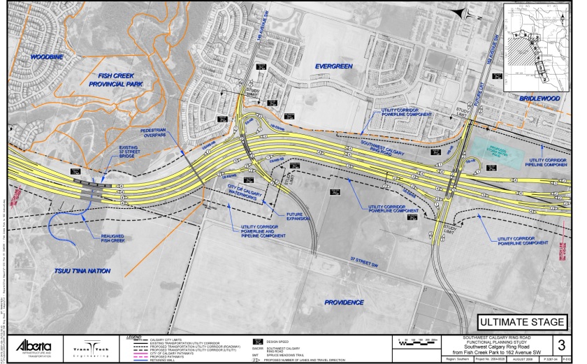
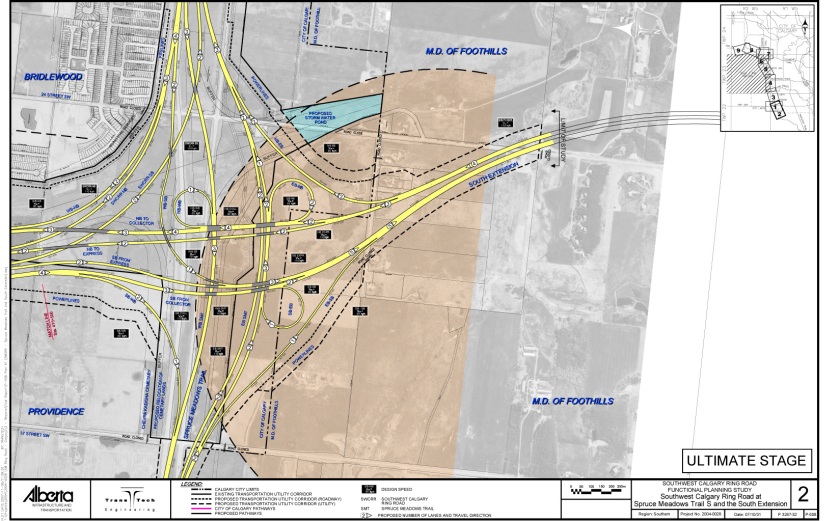
The following diagrams are of the ‘Ultimate Stage’ of the Southwest Calgary Ring Road, taken from their Functional Planning Study. The number in the circles on the road indicate lane count. Please click on the images to see a much larger version. (Note the direction of North, as the orientation changes from diagram to diagram).
101st Street SW and Highway 8 to 69th Street SW. This section splits Stoney Trail (Calgary Ring Road) traffic from Highway 8 traffic. It includes the 69th street Interchange.


These maps are useless. I live in the Cedarbrae area. The map legends do not indicate what the orange boundary lines represent, and on the map for near Anderson Road there remains a City walking path in pink but nothing on the map for Southland Drive that indicates any remaining path or park area once the land has been desecrated.
These maps are from the 2006-2009 planning efforts, and have been supplanted by newer maps showing the most recent designs. I will see about posting all of the most recent maps very soon, which I hope are more valuable to you. Thanks!
More recent maps can be found here: https://calgaryringroad.wordpress.com/2016/06/15/2015-southwest-calgary-ring-road-maps/