The origins of the ring road can be traced back to a time when the Trans-Canada highway was first being planned and constructed through Calgary, and the history of these two roads are intertwined. Both the northern and southern potions of the ring road have played a part in the story of the highway in the Calgary area.
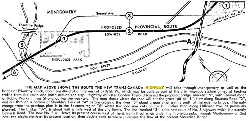
In the mid- to late-1940s the Government of Canada instructed each Province to select a route for the Trans-Canada highway through their territory. By 1949, in conjunction with BC and Saskatchewan, Alberta decided on a general route that would travel through Calgary, as opposed to a more northern route through Edmonton or a more southern route through the Crowsnest Pass. Although the highway would ultimately travel through the city via 16th avenue north and Bowness, other alignments were studied before a final route was decided upon.
Early in the process the City of Calgary had proposed a route for the highway that would have seen the road cross the Bow River at the Shaganappi Trail and head southwest through what is now Edworthy park (road ‘A’ shown in the map above). This river crossing was also part of the city’s ring road plans at the time, but was rejected by the Province for the Trans-Canada alignment, preferring a crossing at Shouldice instead.
The Northwest Bypass
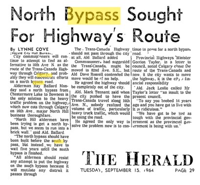
In 1964, despite having agreed to the location of the Trans-Canada highway on 16th avenue only 14 years earlier, the City wanted to look at alternative routes. 16th avenue had seen a steady increase in traffic since becoming the Trans-Canada route, and alternatives, including a new route north of the city, were sought to relieve the congestion.
An alternative routing to the north was both welcomed (by those who wanted to reduce the congestion on 16th avenue) and criticised (by business owners fearing a loss of customers who would be diverted away from their stores along 16th avenue). However, in the 1960s, as it is today, the City of Calgary was the destination for a significant portion of the Highway 1 traffic. Because most travellers were stopping in Calgary anyway, a bypass route was considered of little value for the cost. Despite this, regular calls for a northwest bypass to be built were made from the 1960s until the ring road was started in the 1990s.
Also in 1964, City commissioners highlighted the possibility of locating the Trans-Canada along 82nd avenue SE. This would form a southern route for the highway which would utilise the newly constructed Glenmore Trail causeway and tie into Sarcee Trail as an alternative path back to the Trans-Canada. Though the negative impacts of this route would prove unpopular with City Council at the time, the southern route would continue to play a role in a potential realignment of the Trans-Canada Highway.
Southern Routes
The suggestion of a southern bypass acting as an alternative to the Trans-Canada Highway officially appears as early as 1957, and was hinted at in 1955 by the Province. As part of the 1957 Major Thoroughfare Plan by the City of Calgary a Trans-Canada Highway alternative route, called the No.1 “B” Highway, is detailed as originating just east of Lake Chestermere, heading southwest to Glenmore Trail, then south to Anderson Road before heading west and north around the west end of the reservoir. This route would have run west from Highway 8, headed in a north westerly direction to join with Highway 1 at the Highway 563/Old Banff Coach Road interchange west of the City.
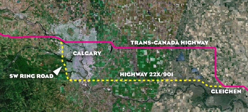
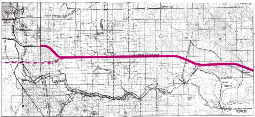
In 1966 the Province of Alberta, in conjunction with municipal districts across the province, began planning for future primary and secondary provincial roads. In the Calgary area this included the Secondary Road Study produced in cooperation with the M.D. of Rocky View and the County of Wheatland which looked at an alternative highway into Calgary from the east, this time towards the south part of the city. Highway 901, also called at the time the Gleichen Freeway, was planned to branch off of the Trans-Canada Highway near Gleichen, Alberta, and head west to become Highway 22x near Calgary. In order to be a true Trans-Canada alternative, traffic could then head north via the proposed southwest ring road alignment and connect to Highway 1 where it meets the Sarcee Trail near Bowness.
The designation of the route as Highway 901 is indicitive of the plan for this road to become a Trans-Canada alternative: Secondary roads in Alberta are given a 900-series number when they are planned as a potential re-alignment of an existing highway. In this case, the 1 at the end of 901 would indicate Highway 1 as the affected highway. Though the road would later cease to be considered as a new alignment of Highway 1, the 901 designation remained.
By 1970 this freeway, though still intended to become an alternative highway route, was not being identified as a full realignment of the Trans-Canada Highway. In the Province’s Calgary Area Study it is noted that the planned extensions of freeways “encourage the use of alternate routes by traffic which would otherwise tend to congest freeways through central Calgary, such as Highway 1…”
The Origins of the Southwest Ring Road?
The concept of a southern alignment of the Trans-Canada highway may have originated even earlier than the 1966 study however. The Tsuut’ina have stated that they were first approached in 1947 about locating the southwest ring road through their reserve. Though there is little detail about what this communication contained, it is interesting to note when it was said to have been made. Calgary did not begin planning for a ring road or bypass road network until the early 1950s, though 1947 would be consistent with the time when the Province was studying potential routes for the Trans-Canada. Given the timing and the manner in which Highway 22x aligns with the Trans-Canada Highway at Gleichen, the possibility exists that the earliest plans for the southwest ring road were not created as part of a ring road system at all, but rather it may have first been considered as a potential location for the Trans-Canada Highway. Though possible, this has not been confirmed at this time.
Moving a Highway
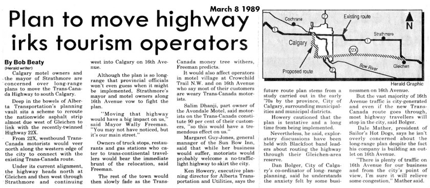
In 1989 the issue of moving the Highway 1 to the south of the city via Highway 22x and the southwest ring road was again raised by Alberta Transportation. Though preliminary in nature, the plans prompted the Province to conduct early discussions with the Siksika Nation about routing the highway through their reserve west of Gleichen.
Work on an upgraded Highway 901 began in 1994, and when finished it provided a 2-lane, lower capacity alternative entrance to Calgary from the southeast.
Stoney Trail and the Trans-Canada
In 2009 the northeast ring road (or northeast Stoney Trail) was opened to traffic, which completed the north section of the road. Connected to the Trans-Canada highway on both the east and west ends of Calgary, the ring road was touted by some as a free-flow alternative to Highway 1, despite some concerns that the road was located too far to the north to act as a convenient bypass. Once open, the 50+ year old concept of a northern bypass had been realised.
Also in 2009 the Alberta Government proposed long-range plans for the realignment of the Trans-Canada Highway east of Calgary. The plans detailed not only an alteration of the existing highway, which would be moved away from Strathmore and continue to utilise 16th avenue in Calgary, but also the realignment and extension of Highway 22x as an equally high-capacity southern freeway into the city.
This plan (shown above) would see Highway 22x moved north from the Highway 901 alignment near Gleichen, which would avoid the Siksika reserve and continue east where it would become Stoney Trail once it entered Calgary. A completed southwest ring road would provide a free-flow route to reconnect to the Trans-Canada highway at the west end of Calgary. These plans were based on a 100-year time frame, and there are no current public plans to implement these designs.
Options Still Open
With recent Provincial studies stating “in the long-term there will be at least two freeway routes entering the Calgary region, both Highways 1 and 22X” it seems unlikely that the Trans-Canada Highway will be re-routed away from 16th avenue. However the desire is there to support an alternative freeway access to, and around, the city. If a high-capacity southwest ring road is implemented and Highway 22x is extended and upgraded towards Gleichen, it will likely form an attractive bypass for those seeking to avoid the congestion of an inner-city route.


Very interesting, thanks for taking the time to lay it all out. Might be worth mentioning how south-west ring-road negotiations fell through with the Tsu T’ina and most aren’t optimistic it’ll be sorted out any time soon.
Thanks for the comment! Though the 2009 deal fell through, negotiations have resumed as of 2011, and are still ongoing. The articles on my blog cover many other aspects of this road, and the rejection of the 2009 deal is covered in detail here: https://calgaryringroad.wordpress.com/2012/05/04/the-2009-agreement/
The south path is still lacking some planing, as the bridges over the Bow river and Mcloud are not included in this proposal. One is already a bottle neck and the other will show that reducing 3 lanes to 2 to again expand to 3 could be little functional (anyone driving at Deerfoot knows that); the other, well, there are plans for 2014, but really is a long shoot for te way top planners do things here in Calgary
Thank you for posting this! The City missed out on a better routes for a major east-west highway. There was the 1960’s TCH Freeway plan that would have put a major freeway down 24 Ave N (http://albertaroads.homestead.com/Calgary/plans/index.html) but was killed due to public opposition. If it was designated sooner, McKnight Blvd with a combination of John Laurie Blvd and Shaganappi Tr probably could have worked as an alternative to the 24 Ave freeway accompanied with Stoney Trail as a bypass. I’m a little surprised that Glenmore & Sarcee Trail alignments have not been explored further.
An interesting plan the currently exists is that the province wants to twin Hwy 560 (Glenmore Trail) between Calgary and Langdon and convert into a freeway(http://www.transportation.alberta.ca/projects/calgary.aspx & http://www.transportation.alberta.ca/projects/assets/Area_7_Calgary_Area/Hwy_560/Recomended_plan.pdf). If there was ever an extension of this freeway so it connects with Hwy 1 west of Strathmore, it could produce a free-flow alternative for Hwy 1 through Calgary via an upgraded Glenmore Trail & Sarcee Trail and bypass the Siksika First Nation, unlike the Hwy 901/22X plan.
Thanks for the comment, and interesting links! The longer-range plans for Highway 22x do avoid the Siksika First Nation, though it would be interesting to see what role an upgraded Glenmore Trail would play in those plans.